Weather and Climate Synopsis
|
|
County, Illinois Weather and Climate Synopsis |

[National] [International] [Learning] [EWOCK] [Reg Clim Ctrs] |
(Click image to zoom) or
Click Here
Satellite images from NOAA
Also see NWS Watch/Warning Maps |
A joint service of the UK Ag Weather Center and the National Weather Service.
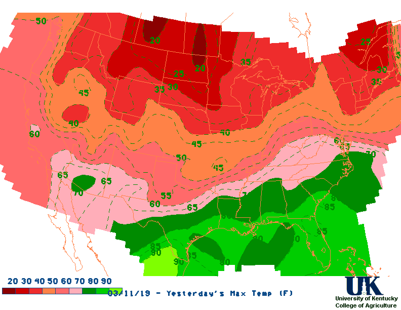
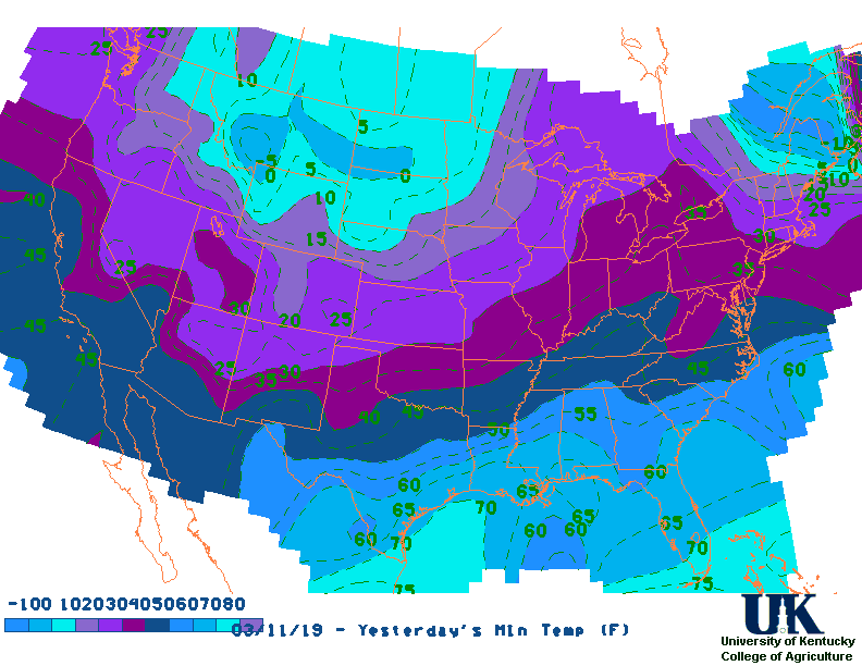
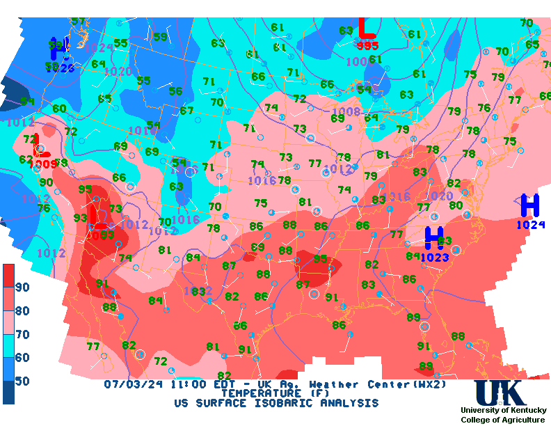
![]() Current Surface Map, [TWC], Yesterday's Highs , Lows
Current Surface Map, [TWC], Yesterday's Highs , Lows ![]() Map of 24 Hr Rainfall (7AM - 7AM EST), 7 Day Rainfall Animation
Map of 24 Hr Rainfall (7AM - 7AM EST), 7 Day Rainfall Animation
NORTHWEST ILLINOIS

CITY           SKY/WX    TMP DP  RH WIND       PRES   REMARKS
MOLINE         SUNNY     69  34  27 S13       30.03F TC  21
6HR MIN TEMP:  40; 6HR MAX TEMP:  70;

SAVANNA*       SUNNY     70  34  26 S14       30.03F TC  21
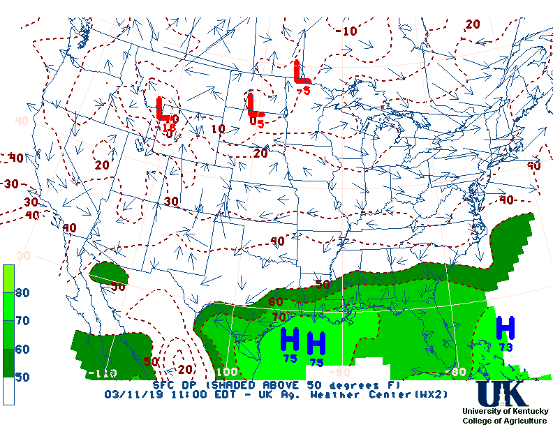
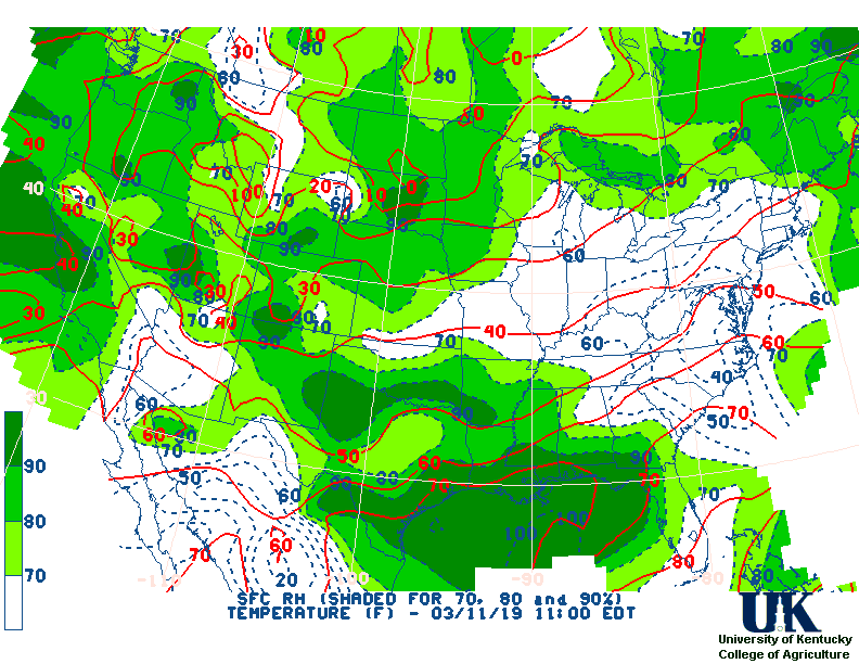
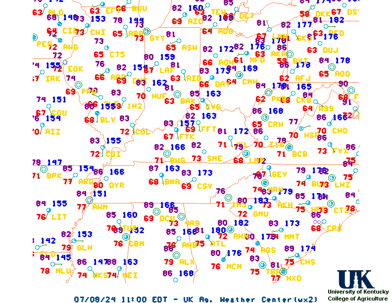
![]() Current Temperatures, Dewpoint Map, RH, Wind, Regional Obs, Surface 4-Panel
Current Temperatures, Dewpoint Map, RH, Wind, Regional Obs, Surface 4-Panel
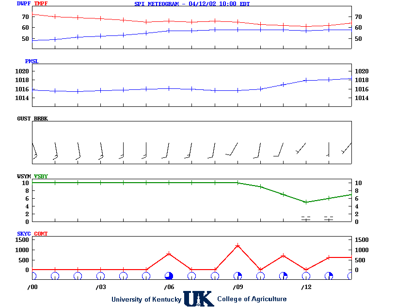
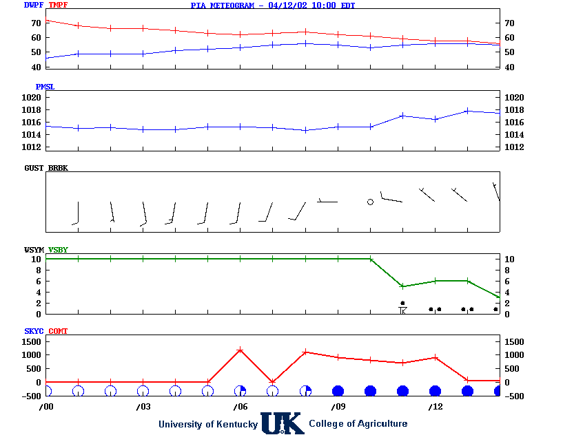
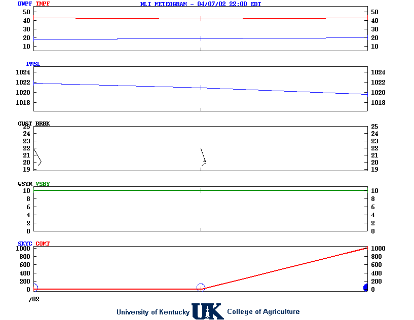
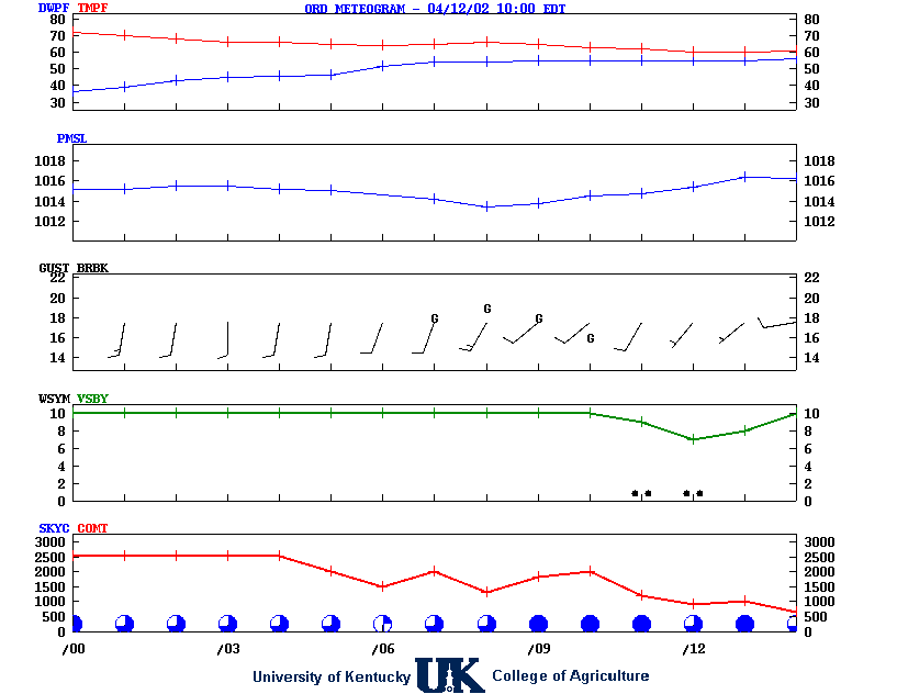
![]() Meteograms : Springfield , Peoria , Quad City , Chicago (O'Hare) , Rockford
Meteograms : Springfield , Peoria , Quad City , Chicago (O'Hare) , Rockford
.THIS AFTERNOON...Sunny. Highs in the mid 70s. Southwest winds
10 to 15 mph with gusts up to 25 mph.
.TONIGHT...Clear. Lows in the mid 40s. South winds 5 to 10 mph.
.THURSDAY...Sunny. Highs in the upper 70s. South winds around
5 mph, becoming northeast in the afternoon.
.THURSDAY NIGHT...Mostly clear in the evening, then becoming
mostly cloudy. Lows in the lower 50s. Northeast winds 5 to
10 mph.
.FRIDAY...Sunny. Highs in the lower 70s. Northeast winds 5 to
10 mph.
.FRIDAY NIGHT AND SATURDAY...Clear. Lows in the upper 40s. Highs
in the lower 80s.
.SATURDAY NIGHT AND SUNDAY...Mostly clear. Lows in the mid 50s.
Highs in the lower 70s.
.SUNDAY NIGHT...Clear, cooler with lows in the lower 40s.
.MONDAY THROUGH TUESDAY...Mostly clear. Highs around 70. Lows in
the lower 40s.
![]() 12-48 Hr Surface, 12-48 Hr ETA 500mb/Sfc, TWC Forecast, Fire Danger, Day 1 Precip, Day 2
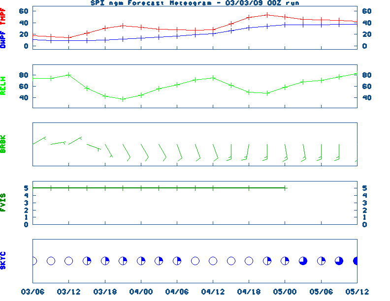
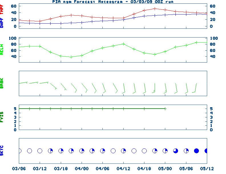
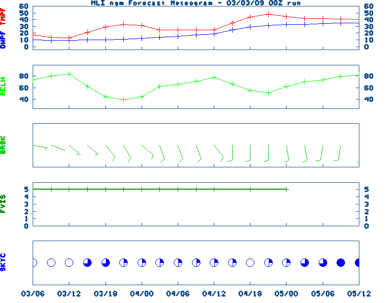
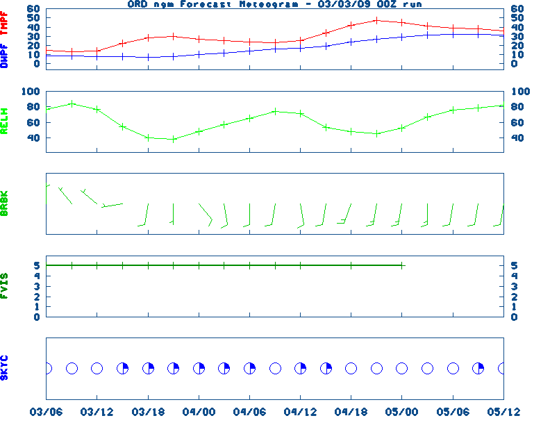
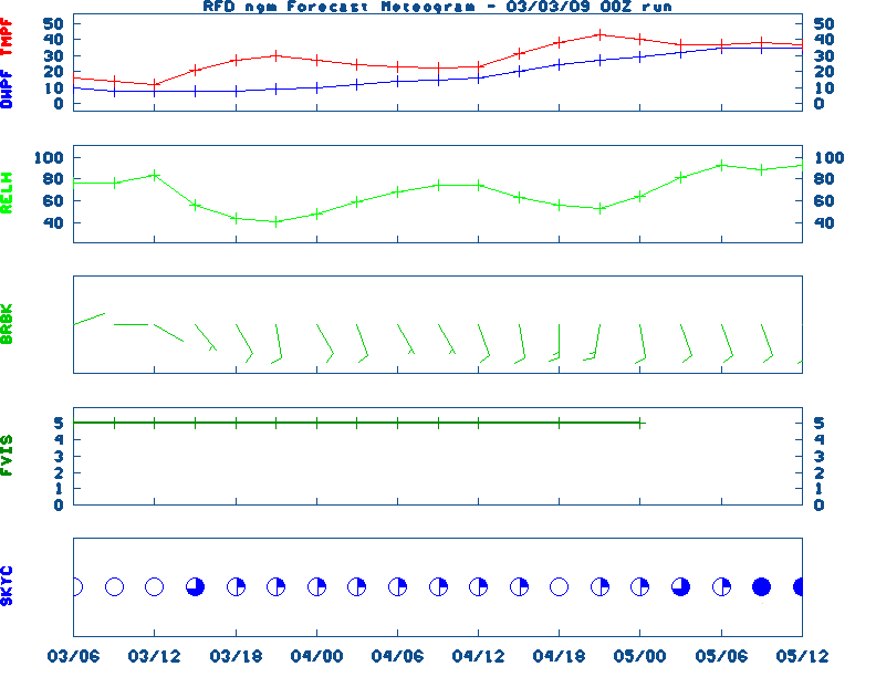
12-48 Hr Surface, 12-48 Hr ETA 500mb/Sfc, TWC Forecast, Fire Danger, Day 1 Precip, Day 2![]() NGM 60 Hr Forecast Meteograms : Springfield , Peoria , Quad City , Chicago (O'Hare) , Rockford ,
NGM 60 Hr Forecast Meteograms : Springfield , Peoria , Quad City , Chicago (O'Hare) , Rockford ,
                 6 TO 10 DAY  8 TO 14 DAY   30 DAY    90 DAY     120 DAY    180 DAY
                                           NOV05   NOV05-JAN06 DEC05-FEB06 FEB06-APR06
                 -----------  -----------  --------  ---------  ---------  ---------
   Temperature:      Below        Below      Above     Normal     Normal     Normal
 Precipitation:      Below        Below     Normal     Normal     Normal     Normal

....  Medium and long range outlooks provided by NCEP/K. Thomas Priddy
---------------------------
OCTOBER 2ND
HISTORIC WEATHER EVENTS
...1882...
An early season windstorm over Oregon and northern California blew down
thousands of trees and caused great crop damage in the Sacramento Valley.
(David Ludlum)
...1898...
A hurricane struck the Georgia coast washing away Campbell Island. (David
Ludlum)
...1959...
A tornado struck the town of Ivy VA (located near Charlottesville). Eleven
persons were killed, including ten from one family. (The Weather Channel)
...1980...
The temperature at Blue Canyon CA soared to 88 degrees, an October record
for that location. (The Weather Channel)
...1981...
Severe thunderstorms raked Phoenix AZ with heavy rain, high winds, and hail
up to an inch and a half in diameter, for the second day in a row.
Thunderstorms on the 1st deluged Phoenix with .68 inch of rain in five
minutes, equalling their all-time record. (The Weather Channel)
...1987...
A fast moving cold front produced snow flurries from Minnesota to the
Appalachian Mountains, and gale force winds behind the front ushered cold
air into the Great Lakes Region. Valentine NE reported a record low of 25
degrees. Temperatures recovered rapidly in the Northern High Plains Region,
reaching the lower 80s by afternoon. Jackson WY warmed from a morning low
of 21 degrees to an afternoon high of 76 degrees. (The National Weather
Summary)
...1988...
Early morning thunderstorms in Georgia produced three inches of rain at
Canton and Woodstock. (The National Weather Summary)
...1989...
Flooding due to thunderstorm rains in the southeastern U.S. on the last day
of September and the first day of October caused the Etowah River to rise
seven feet above flood stage at Canton GA. Thunderstorms produced up to ten
inches of rain in northeastern Georgia, with six inches reported at Athens
GA in 24 hours. One man was killed, and another man was injured, when
sucked by floodwaters into drainage lines. (The National Weather Summary)
(Storm Data)
|
|
|
![[TWC]](http://www.weather.com/images/maps/current/curwx_440x275.gif)